
Standerton topographic map
Click on the map to display elevation.
About this map
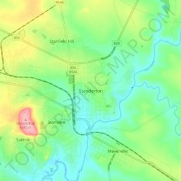
Name: Standerton topographic map, elevation, terrain.
Average elevation: 1,554 m
Minimum elevation: 1,511 m
Maximum elevation: 1,642 m
Other topographic maps
Click on a map to view its topography, its elevation and its terrain.
Grootdraai Dam
South Africa > Mpumalanga > Gert Sibande > Lekwa Local Municipality
Average elevation: 1,549 m
Grootdraai Dam
South Africa > Mpumalanga > Gert Sibande > Lekwa Local Municipality
Average elevation: 1,549 m
Blesbokspruit
South Africa > Mpumalanga > Gert Sibande > Lekwa Local Municipality
Average elevation: 1,606 m