
Fort Mill topographic map
Interactive map
Click on the map to display elevation.
About this map
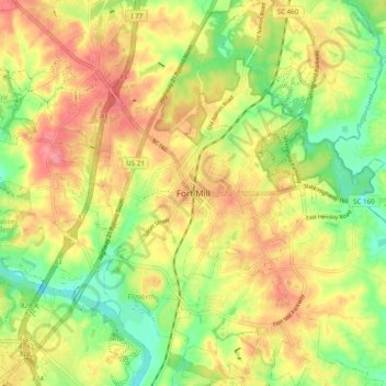
Name: Fort Mill topographic map, elevation, terrain.
Location: Fort Mill, York County, South Carolina, 29716, United States (34.96737 -80.98508 35.04737 -80.90508)
Average elevation: 182 m
Minimum elevation: 142 m
Maximum elevation: 218 m
Other topographic maps
Click on a map to view its topography, its elevation and its terrain.
Old Orchid
United States > South Carolina > York County > Fort Mill > Old Orchid
Old Orchid, Fort Mill, York County, South Carolina, 29715, United States
Average elevation: 184 m