
Thank you for supporting this site ❤️
Make a donation
Make a donation
Tatarstan topographic map
Click on the map to display elevation.
Thank you for supporting this site ❤️
Make a donation
Make a donation
About this map
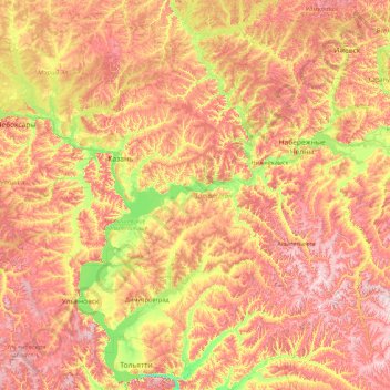
Name: Tatarstan topographic map, elevation, terrain.
Location: Tatarstan, Volga Federal District, Russia (53.97424 47.23702 56.67817 54.26570)
Average elevation: 147 m
Minimum elevation: 25 m
Maximum elevation: 381 m
Thank you for supporting this site ❤️
Make a donation
Make a donation
Other topographic maps
Click on a map to view its topography, its elevation and its terrain.
Thank you for supporting this site ❤️
Make a donation
Make a donation
Thank you for supporting this site ❤️
Make a donation
Make a donation
Thank you for supporting this site ❤️
Make a donation
Make a donation
Thank you for supporting this site ❤️
Make a donation
Make a donation
Novoromanovka
Russia > Republic of Dagestan > Tarumovsky District > Novoromanovka
Average elevation: -8 m
Thank you for supporting this site ❤️
Make a donation
Make a donation
Thank you for supporting this site ❤️
Make a donation
Make a donation