
Manyii topographic map
Click on the map to display elevation.
About this map
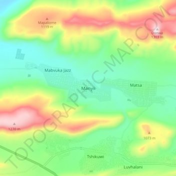
Name: Manyii topographic map, elevation, terrain.
Average elevation: 912 m
Minimum elevation: 690 m
Maximum elevation: 1,297 m
Other topographic maps
Click on a map to view its topography, its elevation and its terrain.
Nzhelele
South Africa > Limpopo > Vhembe District Municipality > Makhado Local Municipality
Average elevation: 675 m
Entabeni Forest Reserve
South Africa > Limpopo > Vhembe District Municipality > Makhado Local Municipality
Average elevation: 1,145 m