
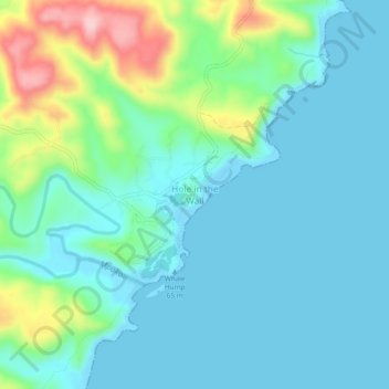
Hole in the Wall topographic map
Interactive map
Click on the map to display elevation.
About this map
Name: Hole in the Wall topographic map, elevation, terrain.
Average elevation: 44 m
Minimum elevation: 0 m
Maximum elevation: 205 m
Other topographic maps
Click on a map to view its topography, its elevation and its terrain.
Efeta
South Africa > Eastern Cape > O.R. Tambo District Municipality > King Sabata Dalindyebo Local Municipality
Efeta, King Sabata Dalindyebo Local Municipality, O.R. Tambo District Municipality, Eastern Cape, 5099, South Africa
Average elevation: 709 m
Qunu
South Africa > Eastern Cape > O.R. Tambo District Municipality > King Sabata Dalindyebo Local Municipality
Qunu, King Sabata Dalindyebo Local Municipality, O.R. Tambo District Municipality, Eastern Cape, South Africa
Average elevation: 814 m
Mthatha River
South Africa > Eastern Cape > O.R. Tambo District Municipality > King Sabata Dalindyebo Local Municipality
Mthatha River, King Sabata Dalindyebo Local Municipality, O.R. Tambo District Municipality, Eastern Cape, 5100, South Africa
Average elevation: 715 m
Viedgesville
South Africa > Eastern Cape > O.R. Tambo District Municipality > King Sabata Dalindyebo Local Municipality
Viedgesville, King Sabata Dalindyebo Local Municipality, O.R. Tambo District Municipality, Eastern Cape, South Africa
Average elevation: 890 m
Nduli Wildlife Sanctuary
South Africa > Eastern Cape > O.R. Tambo District Municipality > King Sabata Dalindyebo Local Municipality > Mount Pleasant
Nduli Wildlife Sanctuary, R61, Pola Park, King Sabata Dalindyebo Ward 11, Mount Pleasant, King Sabata Dalindyebo Local Municipality, O.R. Tambo District Municipality, Eastern Cape, 5100, South Africa
Average elevation: 733 m
Umtata Central
South Africa > Eastern Cape > O.R. Tambo District Municipality > King Sabata Dalindyebo Local Municipality > Umtata Central
Umtata Central, King Sabata Dalindyebo Local Municipality, O.R. Tambo District Municipality, Eastern Cape, 5100, South Africa
Average elevation: 724 m
Sheshegu
South Africa > Eastern Cape > O.R. Tambo District Municipality > King Sabata Dalindyebo Local Municipality > Sheshegu
Sheshegu, King Sabata Dalindyebo Local Municipality, O.R. Tambo District Municipality, Eastern Cape, 5099, South Africa
Average elevation: 718 m
Coffee Bay
South Africa > Eastern Cape > O.R. Tambo District Municipality > King Sabata Dalindyebo Local Municipality
Coffee Bay, King Sabata Dalindyebo Local Municipality, O.R. Tambo District Municipality, Eastern Cape, South Africa
Average elevation: 40 m