
Referinghausen topographic map
Interactive map
Click on the map to display elevation.
About this map
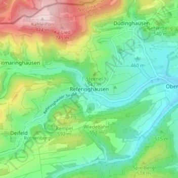
Name: Referinghausen topographic map, elevation, terrain.
Average elevation: 532 m
Minimum elevation: 413 m
Maximum elevation: 776 m
Other topographic maps
Click on a map to view its topography, its elevation and its terrain.
Rothenberg
Deutschland > Nordrhein-Westfalen > Hochsauerlandkreis > Medebach
Rothenberg, Medebach, Hochsauerlandkreis, Nordrhein-Westfalen, 59964, Deutschland
Average elevation: 533 m
Dreislar
Deutschland > Nordrhein-Westfalen > Hochsauerlandkreis > Medebach > Dreislar
Dreislar, Medebach, Hochsauerlandkreis, Nordrhein-Westfalen, Deutschland
Average elevation: 420 m
Düdinghausen
Deutschland > Nordrhein-Westfalen > Hochsauerlandkreis > Medebach
Düdinghausen, Medebach, Hochsauerlandkreis, Nordrhein-Westfalen, Deutschland
Average elevation: 540 m