
Langa topographic map
Interactive map
Click on the map to display elevation.
About this map
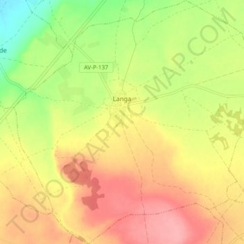
Name: Langa topographic map, elevation, terrain.
Location: Langa, Ávila, Castile and León, Spain (40.97527 -4.89068 41.02959 -4.81881)
Average elevation: 869 m
Minimum elevation: 814 m
Maximum elevation: 913 m
Other topographic maps
Click on a map to view its topography, its elevation and its terrain.
Fuentepelayo
Fuentepelayo, Segovia, Castile and León, 40260, Spain
Average elevation: 875 m
Ayllón
Ayllón, Segovia, Castile and León, 40520, Spain
Average elevation: 1,123 m
San Justo
Spain > Castile and León > San Justo
San Justo, Galende, Castile and León, Spain
Average elevation: 1,332 m
La Tala
Spain > Castile and León > La Tala
La Tala, Guijuelo, Castile and León, Spain
Average elevation: 946 m
La Maya
Spain > Castile and León > La Maya
La Maya, Peñaranda de Bracamonte, Castile and León, Spain
Average elevation: 850 m
Burgos
Spain > Castile and León > Burgos
Burgos, Alfoz de Burgos, Burgos, Castile and León, Spain
Average elevation: 907 m
Velilla del Río Carrión
Spain > Castile and León > Velilla del Río Carrión
Velilla del Río Carrión, Palencia, Castile and León, 34886, Spain
Average elevation: 1,456 m
El Espinar
Spain > Castile and León > El Espinar
El Espinar, Segovia, Castile and León, Spain
Average elevation: 1,324 m
Pico Almanzor
Spain > Castile and León > Candeleda
Pico Almanzor, Candeleda, Comarca de Arenas de San Pedro, Ávila, Castile and León, Spain
Average elevation: 2,159 m
Atua
Spain > Castile and León > Condado de Treviño
Atua, Condado de Treviño, Ebro, Burgos, Castile and León, Spain
Average elevation: 629 m
Contreras
Spain > Castile and León > Contreras
Contreras, Sierra de la Demanda, Burgos, Castile and León, Spain
Average elevation: 1,089 m