
Thank you for supporting this site ❤️
Make a donation
Make a donation
Castelo de Paiva topographic map
Click on the map to display elevation.
Thank you for supporting this site ❤️
Make a donation
Make a donation
About this map
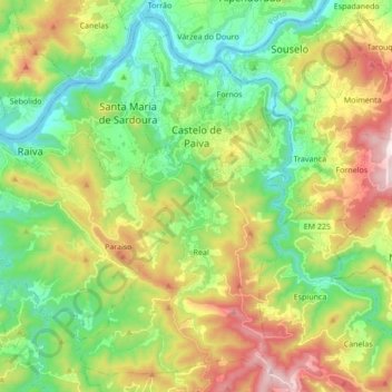
Name: Castelo de Paiva topographic map, elevation, terrain.
Location: Castelo de Paiva, Aveiro, Portugal (40.96226 -8.40092 41.08015 -8.22995)
Average elevation: 272 m
Minimum elevation: 6 m
Maximum elevation: 741 m
Thank you for supporting this site ❤️
Make a donation
Make a donation
Other topographic maps
Click on a map to view its topography, its elevation and its terrain.
Thank you for supporting this site ❤️
Make a donation
Make a donation