
Hadramaut Governorate topographic map
Interactive map
Click on the map to display elevation.
About this map
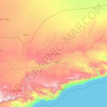
Name: Hadramaut Governorate topographic map, elevation, terrain.
Location: Hadramaut Governorate, Yemen (13.84273 46.30630 19.00000 52.00000)
Average elevation: 692 m
Minimum elevation: 0 m
Maximum elevation: 2,398 m
Other topographic maps
Click on a map to view its topography, its elevation and its terrain.
Sana'a
At an elevation of 2,300 metres (7,500 ft), Sanaa is one of the highest capital cities in the world and is next to the Sarawat Mountains of Jabal An-Nabi Shu'ayb and Jabal Tiyal, considered to be the highest mountains in the Arabian Peninsula and one of the highest in the region. Sanaa has a population of…
Average elevation: 2,443 m