
Make a donation
Roodeplaat Dam topographic map
Click on the map to display elevation.
Make a donation
About this map
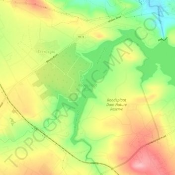
Name: Roodeplaat Dam topographic map, elevation, terrain.
Average elevation: 1,240 m
Minimum elevation: 1,163 m
Maximum elevation: 1,313 m
Make a donation
Other topographic maps
Click on a map to view its topography, its elevation and its terrain.
Tshwane Ward 83
South Africa > Gauteng > City of Tshwane Metropolitan Municipality
Average elevation: 1,498 m
Struben Dam
South Africa > Gauteng > City of Tshwane Metropolitan Municipality > Pretoria
Average elevation: 1,385 m
Rietvlei Nature Reserve
South Africa > Gauteng > City of Tshwane Metropolitan Municipality
Rietvlei Nature Reserve, located in southern Pretoria, is about 4,000 hectares (40 km2) in size, and includes the entirety of the Rietvlei Dam which impounds the Rietvlei River, in Gauteng, South Africa. The reserve is wedged between the R21 highway (OR Tambo Airport highway) on the western side and the R50…
Average elevation: 1,519 m
Tshwane Ward 47
South Africa > Gauteng > City of Tshwane Metropolitan Municipality
Average elevation: 1,523 m
Make a donation
Apies River
South Africa > Gauteng > City of Tshwane Metropolitan Municipality
Average elevation: 1,224 m
Dinokeng Game Reserve
South Africa > Gauteng > City of Tshwane Metropolitan Municipality > Mongena Game Lodge
Average elevation: 1,119 m
Tshwane Ward 48
South Africa > Gauteng > City of Tshwane Metropolitan Municipality
Average elevation: 1,363 m