
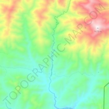
Twee Riviere topographic map
Interactive map
Click on the map to display elevation.
About this map
Name: Twee Riviere topographic map, elevation, terrain.
Average elevation: 955 m
Minimum elevation: 583 m
Maximum elevation: 1,682 m
Other topographic maps
Click on a map to view its topography, its elevation and its terrain.
Kaaimans River
South Africa > Western Cape > George Local Municipality
Kaaimans River, George Local Municipality, Garden Route District Municipality, Western Cape, 6560, South Africa
Average elevation: 403 m
Eersterivier
South Africa > Western Cape > George Local Municipality
Eersterivier, George Local Municipality, Garden Route District Municipality, Western Cape, South Africa
Average elevation: 742 m