
Gegharkunik topographic map
Interactive map
Click on the map to display elevation.
About this map
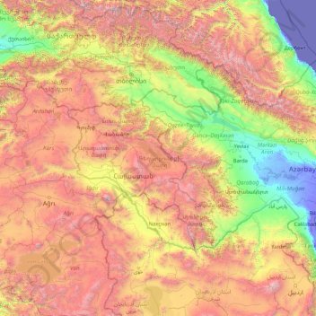
Name: Gegharkunik topographic map, elevation, terrain.
Location: Gegharkunik, Armenia (37.70307 42.77574 42.90307 47.97574)
Average elevation: 1,442 m
Minimum elevation: -30 m
Maximum elevation: 4,882 m
Other topographic maps
Click on a map to view its topography, its elevation and its terrain.
Vagharshapat
The city has an average elevation of 853 metres (2,799 feet) above sea level. The climate is cold semi-arid (Köppen climate classification BSk).
Average elevation: 868 m