
Gundagai topographic map
Interactive map
Click on the map to display elevation.
About this map
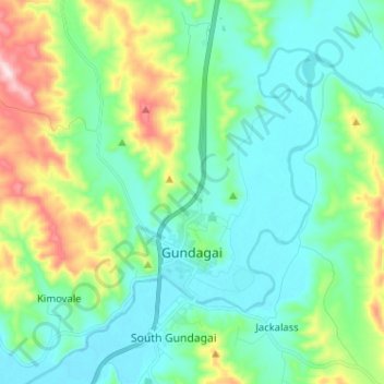
Name: Gundagai topographic map, elevation, terrain.
Average elevation: 309 m
Minimum elevation: 208 m
Maximum elevation: 622 m
Other topographic maps
Click on a map to view its topography, its elevation and its terrain.
Canberra
The area chosen for the capital had been inhabited by Indigenous Australians for up to 21,000 years, with the principal group being the Ngunnawal people. European settlement commenced in the first half of the 19th century, as evidenced by surviving landmarks such as St John's Anglican Church and Blundells…
Average elevation: 638 m
Perth
Australia > Western Australia > City of Perth
Perth, the capital of Western Australia, is situated on the Swan Coastal Plain, a flat expanse of sandy soil nestled between the Indian Ocean to the west and the Darling Scarp to the east. The Darling Scarp, also known as the Darling Range, is a low escarpment that extends north–south, marking a distinct…
Average elevation: 26 m
Cairns
South of Smithfield and inland from the Northern Beaches along the edge of the Barron River flood plain are the suburbs of Caravonica, Kamerunga, Freshwater, and Stratford. This area is sometimes referred to as Freshwater Valley, though it is actually the lower part of Redlynch Valley; further up the valley…
Average elevation: 176 m
Mount Kembla
The summit of Mount Kembla has an elevation of 534 metres (1,752 ft) above sea level.
Average elevation: 227 m
Ellis Park
Australia > South Australia > Adelaide City Council > Adelaide
Adelaide is a planned city, and the Adelaide Park Lands are an integral part of Colonel William Light's 1837 plan. Light chose a site spanning the River Torrens (known as Yatala by the Kaurna people), and planned the city to fit the topography of the landscape, "on rising ground".
Average elevation: 33 m