
Manila topographic map
Interactive map
Click on the map to display elevation.
Manila
Almost all of Manila sits on top prehistoric alluvial deposits built by the waters of the Pasig River and on land reclaimed from Manila Bay. Manila's land has been substantially altered by human intervention; there has been considerable land reclamation along the waterfronts since the early-to-mid twentieth century. Some of the city's natural variations in topography have been leveled. As of 2013, Manila had a total area of 42.88 square kilometres (16.56 sq mi).
About this map
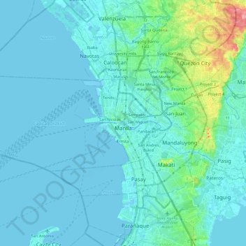
Name: Manila topographic map, elevation, terrain.
Location: Manila, Capital District, Metro Manila, Philippines (14.55082 120.79170 14.63955 121.02617)
Average elevation: 12 m
Minimum elevation: -3 m
Maximum elevation: 106 m
Other topographic maps
Click on a map to view its topography, its elevation and its terrain.
Antipolo
Its higher elevation than that of Metro Manila affords it a scenic view of the metropolis, especially at night. Its locally grown mangoes and cashews are popular among tourists, as well as suman – a local delicacy made out of glutinous rice. The Hinulugang Taktak National Park, which was once a popular…
Average elevation: 125 m
Magat Dam
Philippines > Isabela > Santiago
Storage Capacity at Full Supply Level (FSL): 1.08 billion cubic meters Elevation at FSL: 193 masl Minimum Supply Level: 160 masl
Average elevation: 176 m
Muntinlupa
There are three plausible origins of the name of the city: First, is its association with the thin topsoil in the area; second, residents, purportedly replying to a question by Spaniards in the 16th century what the name of their place was, said “Monte sa Lupa”—apparently mistaking the question for what…
Average elevation: 41 m