
Satara topographic map
Interactive map
Click on the map to display elevation.
About this map
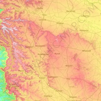
Name: Satara topographic map, elevation, terrain.
Location: Satara, Maharashtra, India (17.09116 73.53447 18.18243 74.90578)
Average elevation: 677 m
Minimum elevation: 46 m
Maximum elevation: 1,433 m
Other topographic maps
Click on a map to view its topography, its elevation and its terrain.
Malegaon
India > Maharashtra > Malegaon Taluka
Malegaon(previously Maligaon) is at the confluence of the Girna and Mosam (previously Moosy) rivers, at elevation of 438 metres (1437 feet) at 18°25′N 77°32′E / 18.42°N 77.53°E / 18.42; 77.53.
Average elevation: 463 m
Nashik
India > Maharashtra > Nashik Taluka
The city's tropical location and high altitude combine to give it a relatively mild version of a tropical wet and dry climate (Köppen Aw). Temperatures rise slightly in October, but this is followed by the cool season from November to February. The cool season sees warm temperatures of around 28 °C or 82.4…
Average elevation: 631 m