
Nagaur topographic map
Interactive map
Click on the map to display elevation.
About this map
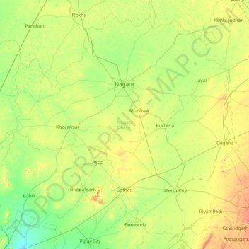
Name: Nagaur topographic map, elevation, terrain.
Location: Nagaur, Rajasthan, India (26.41126 73.08772 27.70807 75.36504)
Average elevation: 339 m
Minimum elevation: 189 m
Maximum elevation: 864 m
Other topographic maps
Click on a map to view its topography, its elevation and its terrain.
Bikaner
India > Rajasthan > Bikaner Tehsil
Around a century after Rao Bika founded Bikaner, the state's fortunes flourished under the sixth Raja, Rai Singhji, who ruled from 1571 to 1611. During the Mughal Empire's rule in the country, Raja Rai Singh accepted the suzerainty of the Mughals and held a high rank as an army general at the court of the…
Average elevation: 225 m