
Pithoragarh topographic map
Interactive map
Click on the map to display elevation.
About this map
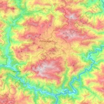
Name: Pithoragarh topographic map, elevation, terrain.
Location: Pithoragarh, Uttarakhand, 262500, India (29.44403 80.09943 29.67038 80.40881)
Average elevation: 1,316 m
Minimum elevation: 421 m
Maximum elevation: 2,454 m
Other topographic maps
Click on a map to view its topography, its elevation and its terrain.
Haridwar
India > Uttarakhand > Haridwar
Haridwar, Hardwar, Haridwar, Uttarakhand, 249401, India
Average elevation: 360 m
Dehradun
India > Uttarakhand > Dehradun
Dehradun, Dehra Dūn, Dehradun, Uttarakhand, 248001, India
Average elevation: 904 m
Pindar Glacier
Pindar Glacier, Bageshwar, Uttarakhand, India
Average elevation: 4,447 m
Milam Glacier
Milam Glacier, Pithoragarh, Uttarakhand, India
Average elevation: 5,223 m
Pithoragarh
India > Uttarakhand > Pithoragarh
Pithoragarh, Uttarakhand, 262500, India
Average elevation: 1,618 m
Bāgeshwar
India > Uttarakhand > Bāgeshwar
Bāgeshwar, Bageshwar, Uttarakhand, 263642, India
Average elevation: 1,154 m