
Edmonson County topographic map
Interactive map
Click on the map to display elevation.
About this map
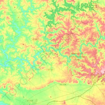
Name: Edmonson County topographic map, elevation, terrain.
Location: Edmonson County, Kentucky, United States (37.05312 -86.46872 37.34086 -86.04896)
Average elevation: 196 m
Minimum elevation: 123 m
Maximum elevation: 300 m
Other topographic maps
Click on a map to view its topography, its elevation and its terrain.
Campbell County
Campbell County, Kentucky, United States
Average elevation: 223 m
Lothair
United States > Kentucky > Perry County > Hazard
Lothair, Hazard, Perry County, Kentucky, 41729, United States
Average elevation: 366 m
Harmony Lake Estates
United States > Kentucky > Oldham County > Goshen
Harmony Lake Estates, Goshen, Oldham County, Kentucky, 40026, United States
Average elevation: 202 m
Schweizer
United States > Kentucky > Simpson County
Schweizer, Simpson County, Kentucky, United States
Average elevation: 220 m
Thornhill
United States > Kentucky > Jefferson County
Thornhill, Jefferson County, Kentucky, United States
Average elevation: 180 m
Hyden
United States > Kentucky > Hyden
Hyden, Leslie County, Kentucky, United States
Average elevation: 352 m
Lexington
United States > Kentucky > Lexington
Lexington, Fayette County, Kentucky, 40508, United States
Average elevation: 285 m
Rob Roy
United States > Kentucky > Rob Roy
Rob Roy, Ohio County, Kentucky, 42333, United States
Average elevation: 143 m