
Maputo River topographic map
Interactive map
Click on the map to display elevation.
About this map
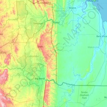
Name: Maputo River topographic map, elevation, terrain.
Location: Maputo River, Inkhundla Tikhuba, Lubombo, Eswatini (-26.86392 31.44680 -26.19283 32.70961)
Average elevation: 206 m
Minimum elevation: -1 m
Maximum elevation: 1,122 m
Other topographic maps
Click on a map to view its topography, its elevation and its terrain.
Mhlume
Eswatini > Lubombo > Inkhundla Mhlume
Mhlume, Inkhundla Mhlume, Lubombo, Eswatini
Average elevation: 263 m
Mhlathuze River
Eswatini > Lubombo > Inkhundla Sithobela
Mhlathuze River, Inkhundla Sithobela, Lubombo, Eswatini
Average elevation: 248 m
Big Bend
Eswatini > Lubombo > Inkhundla Nkilongo > Big Bend
Big Bend, Inkhundla Nkilongo, Lubombo, Eswatini
Average elevation: 124 m