
Thuringia topographic map
Interactive map
Click on the map to display elevation.
About this map
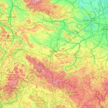
Name: Thuringia topographic map, elevation, terrain.
Location: Thuringia, Germany (50.20435 9.87696 51.64928 12.65392)
Average elevation: 341 m
Minimum elevation: 56 m
Maximum elevation: 1,135 m
Other topographic maps
Click on a map to view its topography, its elevation and its terrain.
Bernterode (bei Worbis)
Germany > Thuringia > Landkreis Eichsfeld > Bernterode (bei Worbis)
Average elevation: 306 m
Kogelberg
Germany > Bavaria > Landkreis Bad Tölz-Wolfratshausen > Lenggries
Average elevation: 1,020 m
Hamburg
The neighborhoods of Neuenfelde, Cranz, Francop and Finkenwerder are part of the Altes Land (old land) region, the largest contiguous fruit-producing region in Central Europe. Neugraben-Fischbek has Hamburg's highest elevation, the Hasselbrack at 116.2 metres (381 ft) AMSL. Hamburg borders the states of…
Average elevation: 56 m
Finkenstein
Germany > Thuringia > Landkreis Schmalkalden-Meiningen > Steinbach-Hallenberg
Average elevation: 723 m
Westerberg
Germany > Lower Saxony > Landkreis Hameln-Pyrmont > Hessisch Oldendorf
Average elevation: 183 m