
South Hills topographic map
Interactive map
Click on the map to display elevation.
About this map
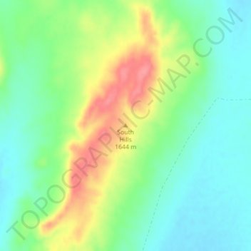
Name: South Hills topographic map, elevation, terrain.
Location: South Hills, Juab County, Utah, United States (39.44074 -111.95776 39.44084 -111.95766)
Average elevation: 1,614 m
Minimum elevation: 1,583 m
Maximum elevation: 1,667 m
Other topographic maps
Click on a map to view its topography, its elevation and its terrain.
Salt Lake City
United States > Utah > Salt Lake County
Salt Lake City has an area of 110.4 square miles (286 km2) and an average elevation of 4,327 feet (1,319 m) above sea level. The lowest point within the boundaries of the city is 4,210 feet (1,280 m) near the Jordan River and the Great Salt Lake, and the highest is Grandview Peak, at 9,410 feet (2,868 m).
Average elevation: 1,592 m
Zion National Park
United States > Utah > Washington County
The 8,726-foot (2,660 m) summit of Horse Ranch Mountain is the highest point in the park; the lowest point is the 3,666-foot (1,117 m) elevation of Coal Pits Wash, creating a relief of about 5,100 feet (1,600 m).
Average elevation: 1,877 m
Tooele County
Tooele County lies on the west side of Utah. Its west border abuts the east border of the state of Nevada. Its northeast border abuts the Great Salt Lake. Three significant mountain ranges run north-south through the county. Its east boundary line is delineated by the crestline of the Oquirrh Mountains, which…
Average elevation: 1,463 m
Moab
United States > Utah > Moab
Moab is just south of the Colorado River, at an elevation of 4,025 feet (1,227 m) on the Colorado Plateau. It is 18 miles (29 km) west of the Utah/Colorado state line. Via U.S. Route 191, it is 31 miles (50 km) south of Interstate 70 at Crescent Junction, and it is 54 miles (87 km) north of Monticello. Via…
Average elevation: 1,357 m