
The Cockscomb topographic map
Interactive map
Click on the map to display elevation.
About this map
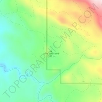
Name: The Cockscomb topographic map, elevation, terrain.
Location: The Cockscomb, Grant County, Oregon, United States (44.94843 -118.83696 44.94853 -118.83686)
Average elevation: 1,271 m
Minimum elevation: 1,134 m
Maximum elevation: 1,496 m
Other topographic maps
Click on a map to view its topography, its elevation and its terrain.
Beaverton
United States > Oregon > Washington County
Beaverton covers a total area of 19.7 square miles (51 km2), all of it land except for small creeks, ponds, and lakes. The city is located along the eastern edge of the Tualatin Valley just west of the Tualatin Mountains. It is bordered by Portland to the east, Hillsboro to the west, and Tigard to the south.…
Average elevation: 106 m
Portland
United States > Oregon > Multnomah County
Annual snowfall in Portland is 4.3 inches (10.9 cm), which usually falls between December and March. The city of Portland avoids snow more frequently than its suburbs, due in part to its low elevation and the urban heat island effect. Neighborhoods outside of the downtown core, especially in slightly higher…
Average elevation: 77 m
Central Point
United States > Oregon > Jackson County
The city lies at an elevation of about 1,272 feet (388 m) along Oregon Highway 99 and Interstate 5 northwest of Medford. Jacksonville is to the south and Gold Hill to the northwest. The Central Oregon and Pacific Railroad passes through Central Point.
Average elevation: 385 m
Ashland
United States > Oregon > Jackson County > Ashland
Ashland lies within Oregon's southwest interior climate zone, in which all but the higher-elevation sites are in the rain shadow of the Oregon Coast Range to the west. The largest urban areas in this zone in addition to Ashland are Medford and Grants Pass in the Rogue Valley, and Roseburg in the Umpqua River…
Average elevation: 774 m
Salem
United States > Oregon > Marion County
Elevation within the city limits ranges from about 120 to 800 feet (37 to 244 m). Salem contains the volcanic Salem Hills in the south and is sandwiched by the 1,000 ft (300 m) Eola Hills directly to the west and the 600 ft (180 m) Waldo Hills to the east. Northern and eastern Salem are less hilly. South and…
Average elevation: 96 m
Tillamook County
According to the United States Census Bureau, the county has a total area of 1,333 square miles (3,450 km2), of which 1,103 square miles (2,860 km2) is land and 230 square miles (600 km2) (17%) is water. At 3,706 feet (1,130 m) in elevation, Rogers Peak is the highest point in the county and the highest in the…
Average elevation: 236 m