
Nottingham Road topographic map
Interactive map
Click on the map to display elevation.
About this map
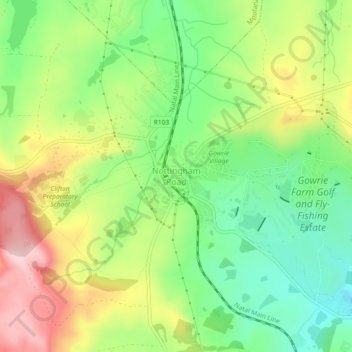
Name: Nottingham Road topographic map, elevation, terrain.
Average elevation: 1,478 m
Minimum elevation: 1,379 m
Maximum elevation: 1,613 m
Other topographic maps
Click on a map to view its topography, its elevation and its terrain.
uMngeni River
South Africa > KwaZulu-Natal > uMgungundlovu District Municipality > uMgeni Local Municipality
Average elevation: 850 m
Midmar Dam
South Africa > KwaZulu-Natal > uMgungundlovu District Municipality > uMgeni Local Municipality > Howick
Average elevation: 1,063 m
Mpofana
South Africa > KwaZulu-Natal > uMgungundlovu District Municipality > uMgeni Local Municipality
Average elevation: 1,332 m
uMngeni
South Africa > KwaZulu-Natal > uMgungundlovu District Municipality > uMgeni Local Municipality
Average elevation: 1,083 m