
Ol Doinyo Lengai topographic map
Interactive map
Click on the map to display elevation.
About this map
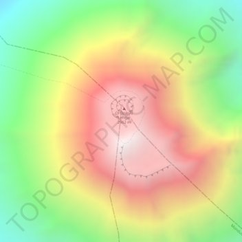
Name: Ol Doinyo Lengai topographic map, elevation, terrain.
Location: Ol Doinyo Lengai, Ngorongoro, Arusha, Northern Zone, Tanzania (-2.76097 35.91371 -2.76087 35.91381)
Average elevation: 2,369 m
Minimum elevation: 1,730 m
Maximum elevation: 2,940 m
Other topographic maps
Click on a map to view its topography, its elevation and its terrain.
Ngorongoro Crater
Ngorongoro Crater, Ngorongoro, Arusha, Northern Zone, Tanzania
Average elevation: 1,963 m
Makao Mapya
Tanzania > Arusha > Makao Mapya
Makao Mapya, Arumeru, Arusha, Northern Zone, Tanzania
Average elevation: 911 m