
Yamuna topographic map
Interactive map
Click on the map to display elevation.
About this map
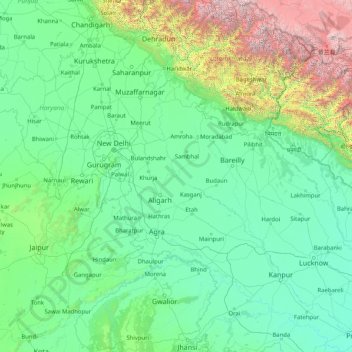
Name: Yamuna topographic map, elevation, terrain.
Location: Yamuna, Firozabad, Uttar Pradesh, 282004, India (25.25727 77.09509 31.02743 81.89233)
Average elevation: 707 m
Minimum elevation: 75 m
Maximum elevation: 7,431 m
Other topographic maps
Click on a map to view its topography, its elevation and its terrain.
Kanpur Dehat District
Kanpur Dehat District, Uttar Pradesh, India
Average elevation: 132 m
Ganges
India > Uttar Pradesh > Ghazipur
Ganges, Ghazipur, Uttar Pradesh, 233001, India
Average elevation: 1,626 m
Nizamabad
Nizamabad, Azamgarh, Uttar Pradesh, 276305, India
Average elevation: 81 m
Beel Akbarpur
India > Uttar Pradesh > Beel Akbarpur
Beel Akbarpur, Ghaziabad, Uttar Pradesh, 201314, India
Average elevation: 208 m