
Make a donation
Overstrand Local Municipality topographic map
Click on the map to display elevation.
Make a donation
About this map
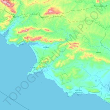
Name: Overstrand Local Municipality topographic map, elevation, terrain.
Average elevation: 142 m
Minimum elevation: -1 m
Maximum elevation: 1,167 m
Make a donation
Other topographic maps
Click on a map to view its topography, its elevation and its terrain.
Hermanus
South Africa > Western Cape > Overberg District Municipality > Overstrand Local Municipality
Average elevation: 87 m
Pringle Bay
South Africa > Western Cape > Overberg District Municipality > Overstrand Local Municipality
Average elevation: 62 m
Onrus River
South Africa > Western Cape > Overberg District Municipality > Overstrand Local Municipality
Average elevation: 232 m
Stanford
South Africa > Western Cape > Overberg District Municipality > Overstrand Local Municipality
Average elevation: 107 m
Make a donation
Salt River
South Africa > Western Cape > Overberg District Municipality > Theewaterskloof Local Municipality
Average elevation: 240 m
Mooiuitsig
South Africa > Western Cape > Overberg District Municipality > Overstrand Local Municipality
Average elevation: 173 m