
Stanford topographic map
Click on the map to display elevation.
About this map
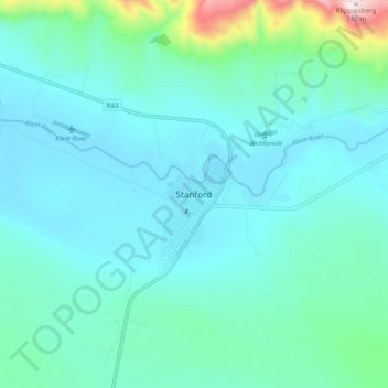
Name: Stanford topographic map, elevation, terrain.
Average elevation: 107 m
Minimum elevation: -2 m
Maximum elevation: 729 m
Other topographic maps
Click on a map to view its topography, its elevation and its terrain.
Pearly Beach
South Africa > Western Cape > Overberg District Municipality > Overstrand Local Municipality
Average elevation: 11 m
Gansbaai
South Africa > Western Cape > Overberg District Municipality > Overstrand Local Municipality
Average elevation: 34 m
Baardskeerdersbos
South Africa > Western Cape > Overberg District Municipality > Overstrand Local Municipality
Average elevation: 120 m
Onrus River
South Africa > Western Cape > Overberg District Municipality > Overstrand Local Municipality
Average elevation: 232 m
Kleinmond
South Africa > Western Cape > Overberg District Municipality > Overstrand Local Municipality
Average elevation: 119 m
Walker Bay
South Africa > Western Cape > Overberg District Municipality > Overstrand Local Municipality
Average elevation: 20 m
Dyer Island
South Africa > Western Cape > Overberg District Municipality > Overstrand Local Municipality
Average elevation: 0 m
Geyser Island
South Africa > Western Cape > Overberg District Municipality > Overstrand Local Municipality
Average elevation: 0 m
Pearly Beach
South Africa > Western Cape > Overberg District Municipality > Overstrand Local Municipality
Average elevation: 11 m
Pearly Beach
South Africa > Western Cape > Overberg District Municipality > Overstrand Local Municipality
Average elevation: 11 m
Walker Bay
South Africa > Western Cape > Overberg District Municipality > Overstrand Local Municipality
Average elevation: 20 m
Onrusrivier
South Africa > Western Cape > Overberg District Municipality > Overstrand Local Municipality
Average elevation: 131 m
Baardskeerdersbos
South Africa > Western Cape > Overberg District Municipality > Overstrand Local Municipality
Average elevation: 120 m