
Vila Nova de Foz Côa topographic map
Interactive map
Click on the map to display elevation.
About this map
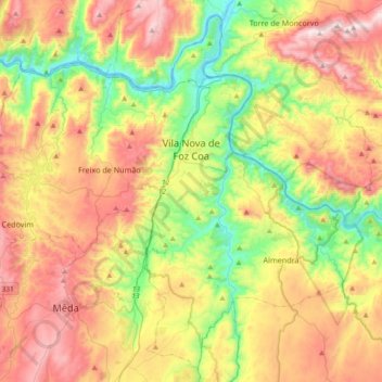
Name: Vila Nova de Foz Côa topographic map, elevation, terrain.
Location: Vila Nova de Foz Côa, Guarda, Portugal (40.92285 -7.34571 41.17935 -6.97667)
Average elevation: 460 m
Minimum elevation: 102 m
Maximum elevation: 908 m
In contrast to what happens in the north-west of Peninsular, in the region of the hot Douro land, the castro civilization has settled not on top of the mountains but on plateaus or small elevations embedded in valleys. Hence, in the first millennium BC, iron men had settled in the zone of the Castle, a place later Romanized and constituted by a small vico, this being evaluated by the area in which the traces of materials of that period predominate. Graves and a funeral inscription (closing with the common acronyms S.T.T.L. - let the earth be light), among other materials, attest to this occupation.
Other topographic maps
Click on a map to view its topography, its elevation and its terrain.