
Gaza Strip topographic map
Interactive map
Click on the map to display elevation.
About this map
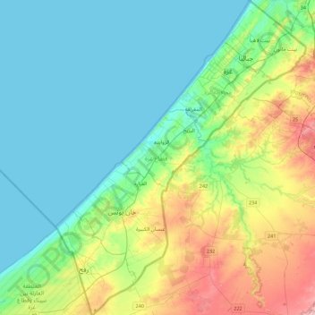
Name: Gaza Strip topographic map, elevation, terrain.
Location: Gaza Strip, Palestinian Territory (31.22013 34.21611 31.59685 34.56732)
Average elevation: 44 m
Minimum elevation: 0 m
Maximum elevation: 170 m
The topography of the Gaza Strip is dominated by three ridges parallel to the coastline, which consist of Pleistocene-Holocene aged calcareous aeolian (wind deposited) sandstones, locally referred to as "kurkar", intercalated with red-coloured fine grained paleosols, referred to as "hamra". The three ridges are separated by wadis, which are filled with alluvial deposits. The terrain is flat or rolling, with dunes near the coast. The highest point is Abu 'Awdah (Joz Abu 'Auda), at 105 m (344 ft) above sea level.
Other topographic maps
Click on a map to view its topography, its elevation and its terrain.
Meithalun
Palestinian Territory > Area A
Meithalun, Area A, West Bank, Palestinian Territory
Average elevation: 403 m
Ramallah
Palestinian Territory > Judea and Samaria > Ramallah
Ramallah, Area A, Judea and Samaria, Palestinian Territory
Average elevation: 795 m
Balata RC
Palestinian Territory > Area A > Balata RC
Balata RC, Nablus Governorate, Area A, Judea and Samaria, 35214, Palestinian Territory
Average elevation: 587 m
Jericho
Palestinian Territory > Area A > Jericho
Jericho, Jericho Governorate, Area A, Judea and Samaria, Palestinian Territory
Average elevation: -244 m
Yabrud
Palestinian Territory > Area B > Yabrud
Yabrud, Area B, Judea and Samaria, 2414, Palestinian Territory
Average elevation: 744 m
Nili
Palestinian Territory > Area C > Nili
Nili, Ramallah and al-Bireh Governorate, Area C, Judea and Samaria, 00970, Palestinian Territory
Average elevation: 297 m
Hebron
Palestinian Territory > Area H1
Hebron, Area H1, West Bank, 150, Palestinian Territory
Average elevation: 901 m