
Tigray topographic map
Interactive map
Click on the map to display elevation.
About this map
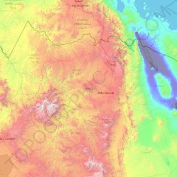
Name: Tigray topographic map, elevation, terrain.
Location: Tigray, Ethiopia (12.25628 36.44639 14.89434 39.99175)
Average elevation: 1,346 m
Minimum elevation: -126 m
Maximum elevation: 4,418 m
Of the 10 largest cities in Tigray, Maychew has the highest elevation at 2479 meter above sea level. Plenty of smaller towns, like Atsbi and Edaga Hamus are located at even higher elevations. Of the large cities, Humera is located at the lowest altitude (585 m).
Other topographic maps
Click on a map to view its topography, its elevation and its terrain.
Butajira
Ethiopia > Southern Nations, Nationalities, and Peoples
Butajira, Guraghe, Southern Nations, Nationalities, and Peoples, Ethiopia
Average elevation: 2,078 m
Blue Nile
Blue Nile, South Gonder, Amhara Region, Ethiopia
Average elevation: 1,649 m
Debre Damo Debir
Debre Damo Debir, Eastern Tigray, Tigray, Ethiopia
Average elevation: 2,045 m
Blue Nile
Ethiopia > Amhara Region > Tis Abay
Blue Nile, Tis Abay, West Gojjam, Amhara Region, Ethiopia
Average elevation: 1,648 m
Koysha dam
Koysha dam, Konta Special Woreda, Southern Nations, Ethiopia
Average elevation: 643 m
Addis Ababa
Ethiopia > Addis Ababa > Arada
Addis Ababa, Arada, Addis Ababa, 3578, Ethiopia
Average elevation: 2,517 m
Dawo
Ethiopia > Oromia Region > Dawo
Dawo, East Harerghe, Oromia Region, Ethiopia
Average elevation: 1,897 m