
Amhara Region topographic map
Interactive map
Click on the map to display elevation.
About this map
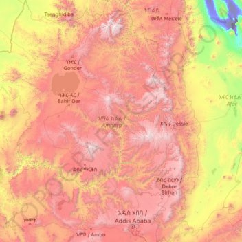
Name: Amhara Region topographic map, elevation, terrain.
Location: Amhara Region, Ethiopia (8.71589 35.26165 13.78090 40.21334)
Average elevation: 1,618 m
Minimum elevation: -114 m
Maximum elevation: 4,454 m
The Amhara region has the most world heritage sites of any region in Ethiopia and is endowed with natural and geographic wonders and ecosystems. The region contains Ethiopia's largest inland body of water Lake Tana, which is the source of the Blue Nile river. In 2015 Lake Tana was recognized as a UNESCO Biosphere Reserve for its enormous biodiversity, and national and international importance. The Semien Mountains National Park has been designated as one of the first natural World Heritage Site by UNESCO in the world, and the very first in Africa in the natural criteria since 1978. Chosen for its spectacular landscapes and global significance for biodiversity conservation. Situated within the Semien Mountains, Ethiopia's highest peaks Ras Dashen reaches an elevation of (4,543 m (14,905 ft)). The park also has Ethiopia's second and third highest mountains, Kidis Yared (4,453 m (14,610 ft)) and Mount Bwahit (4,437 m (14,557 ft)). The park is home to endangered species found nowhere else in the world, examples of endemic fauna include the iconic walia ibex, the gelada baboon, and the Ethiopian wolf (or Simien fox) among others. The wide range of altitudes has given the country a variety of ecologically distinct areas, leading to the evolution of endemic species in ecological isolation.
Other topographic maps
Click on a map to view its topography, its elevation and its terrain.
Butajira
Ethiopia > Southern Nations, Nationalities, and Peoples
Butajira, Guraghe, Southern Nations, Nationalities, and Peoples, Ethiopia
Average elevation: 2,078 m
Blue Nile
Blue Nile, South Gonder, Amhara Region, Ethiopia
Average elevation: 1,649 m
Debre Damo Debir
Debre Damo Debir, Eastern Tigray, Tigray, Ethiopia
Average elevation: 2,045 m
Blue Nile
Ethiopia > Amhara Region > Tis Abay
Blue Nile, Tis Abay, West Gojjam, Amhara Region, Ethiopia
Average elevation: 1,648 m
Koysha dam
Koysha dam, Konta Special Woreda, Southern Nations, Ethiopia
Average elevation: 643 m
Addis Ababa
Ethiopia > Addis Ababa > Arada
Addis Ababa, Arada, Addis Ababa, 3578, Ethiopia
Average elevation: 2,517 m
Dawo
Ethiopia > Oromia Region > Dawo
Dawo, East Harerghe, Oromia Region, Ethiopia
Average elevation: 1,897 m