
Thank you for supporting this site ❤️
Make a donation
Make a donation
Airdrie topographic map
Click on the map to display elevation.
Thank you for supporting this site ❤️
Make a donation
Make a donation
About this map
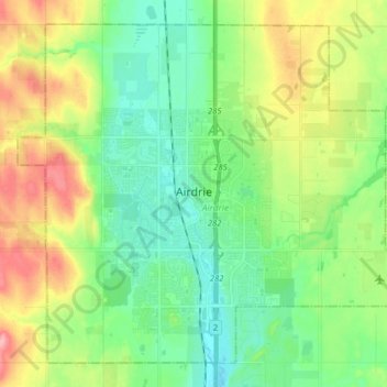
Name: Airdrie topographic map, elevation, terrain.
Location: Airdrie, Alberta, Canada (51.24148 -114.08378 51.32935 -113.92348)
Average elevation: 1,112 m
Minimum elevation: 1,075 m
Maximum elevation: 1,181 m
Thank you for supporting this site ❤️
Make a donation
Make a donation
Other topographic maps
Click on a map to view its topography, its elevation and its terrain.