
Thank you for supporting this site ❤️
Make a donation
Make a donation
Buffelspruit topographic map
Click on the map to display elevation.
Thank you for supporting this site ❤️
Make a donation
Make a donation
About this map
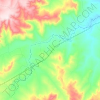
Name: Buffelspruit topographic map, elevation, terrain.
Average elevation: 1,422 m
Minimum elevation: 1,204 m
Maximum elevation: 1,784 m
Thank you for supporting this site ❤️
Make a donation
Make a donation
Other topographic maps
Click on a map to view its topography, its elevation and its terrain.
Badplaas
South Africa > Mpumalanga > Gert Sibande > Albert Luthuli Local Municipality
Average elevation: 1,152 m