
Dortmund topographic map
Interactive map
Click on the map to display elevation.
About this map
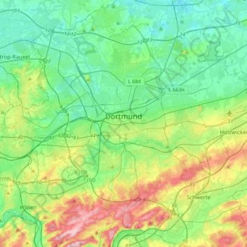
Name: Dortmund topographic map, elevation, terrain.
Location: Dortmund, Renania del Norte-Westfalia, Alemania (51.41553 7.30244 51.60004 7.63816)
Average elevation: 108 m
Minimum elevation: 44 m
Maximum elevation: 273 m
Other topographic maps
Click on a map to view its topography, its elevation and its terrain.
Dortmund
Alemania > Renania del Norte-Westfalia > Dortmund
Dortmund, Regierungsbezirk Arnsberg, Renania del Norte-Westfalia, 44135, Alemania
Average elevation: 112 m