
Make a donation
Baardskeerdersbos topographic map
Click on the map to display elevation.
Make a donation
About this map
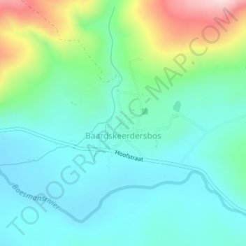
Name: Baardskeerdersbos topographic map, elevation, terrain.
Average elevation: 120 m
Minimum elevation: 44 m
Maximum elevation: 344 m
Make a donation
Other topographic maps
Click on a map to view its topography, its elevation and its terrain.
Hermanus
South Africa > Western Cape > Overberg District Municipality > Overstrand Local Municipality
Average elevation: 87 m
Stanford
South Africa > Western Cape > Overberg District Municipality > Overstrand Local Municipality
Average elevation: 107 m
Onrus River
South Africa > Western Cape > Overberg District Municipality > Overstrand Local Municipality
Average elevation: 232 m
Hawston
South Africa > Western Cape > Overberg District Municipality > Overstrand Local Municipality
Average elevation: 59 m
Make a donation
Dyer Island
South Africa > Western Cape > Overberg District Municipality > Overstrand Local Municipality
Average elevation: 0 m
Geyser Island
South Africa > Western Cape > Overberg District Municipality > Overstrand Local Municipality
Average elevation: 0 m
Pringle Bay
South Africa > Western Cape > Overberg District Municipality > Overstrand Local Municipality
Average elevation: 62 m
Mooiuitsig
South Africa > Western Cape > Overberg District Municipality > Overstrand Local Municipality
Average elevation: 173 m
Make a donation