
Manukau Harbour topographic map
Interactive map
Click on the map to display elevation.
About this map
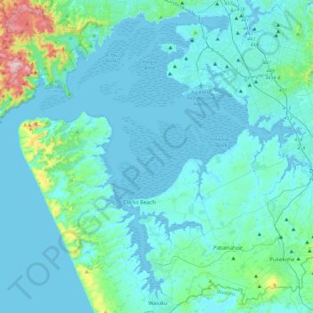
Name: Manukau Harbour topographic map, elevation, terrain.
Location: Manukau Harbour, Auckland, 2022, New Zealand (-37.24789 174.51008 -36.92506 174.94626)
Average elevation: 43 m
Minimum elevation: -2 m
Maximum elevation: 456 m
Other topographic maps
Click on a map to view its topography, its elevation and its terrain.
Auckland
Auckland, Waitematā, Auckland, 1010, New Zealand
Average elevation: 32 m
Auckland Domain
New Zealand > Auckland > Auckland
Auckland Domain, Parnell, Auckland, Waitematā, Auckland, New Zealand
Average elevation: 49 m
North Shore
New Zealand > Auckland > Kaipātiki
North Shore, Tōtara Vale, Kaipātiki, Auckland, 0629, New Zealand
Average elevation: 57 m
Waiheke Island
New Zealand > Auckland > Waiheke
Waiheke Island, Waiheke, Auckland, New Zealand
Average elevation: 16 m
Karekare
New Zealand > Auckland > Waitakere Ranges
Karekare, Waitākere Ranges, Auckland, New Zealand
Average elevation: 112 m
Mount Eden
New Zealand > Auckland > Albert-Eden
Mount Eden, Albert-Eden, Auckland, 1024, New Zealand
Average elevation: 81 m
Maraetai
New Zealand > Auckland > Franklin
Maraetai, Franklin, Auckland, 2018, New Zealand
Average elevation: 22 m
Bethells Beach
New Zealand > Auckland > Waitakere Ranges > Te Henga / Bethells Beach
Bethells Beach, Te Henga / Bethells Beach, Waitākere Ranges, Auckland, New Zealand
Average elevation: 33 m
Waitākere Ranges
Waitākere Ranges, Auckland, New Zealand
Average elevation: 33 m
Waiatarua Reserve
New Zealand > Auckland > Orakei
Waiatarua Reserve, Meadowbank, Ōrākei, Auckland, New Zealand
Average elevation: 42 m
Mahurangi West
New Zealand > Auckland > Rodney
Mahurangi West, Rodney, Auckland, 0983, New Zealand
Average elevation: 27 m
Point England
New Zealand > Auckland > Maungakiekie-Tamaki
Point England, Maungakiekie-Tāmaki, Auckland, 1072, New Zealand
Average elevation: 11 m
Waioneke
New Zealand > Auckland > Rodney
Waioneke, Rodney, Auckland, New Zealand
Average elevation: 27 m
Mokohinau Islands
New Zealand > Auckland > Aotea Great Barrier
Mokohinau Islands, Aotea Great Barrier, Auckland, New Zealand
Average elevation: 2 m
Waimoko Glen
New Zealand > Auckland > Henderson-Massey
Waimoko Glen, Rānui, Henderson-Massey, Auckland, New Zealand
Average elevation: 46 m
Waiatarua
New Zealand > Auckland > Waitakere Ranges
Waiatarua, Waitākere Ranges, Auckland, New Zealand
Average elevation: 216 m
Mangawhai
New Zealand > Auckland > Rodney
Mangawhai, Rodney, Auckland, 0975, New Zealand
Average elevation: 24 m
Stanmore Bay
New Zealand > Auckland > Hibiscus Coast
Stanmore Bay, Hibiscus Coast, Hibiscus and Bays, Auckland, 0932, New Zealand
Average elevation: 18 m
Mahurangi East
New Zealand > Auckland > Rodney
Mahurangi East, Rodney, Auckland, 0983, New Zealand
Average elevation: 15 m
Days Bay
New Zealand > Auckland > Waiheke
Days Bay, Waiheke, Auckland, New Zealand
Average elevation: 34 m
Pukekohe
New Zealand > Auckland > Franklin
Pukekohe, Franklin, Auckland, 2120, New Zealand
Average elevation: 78 m
Waiuku
New Zealand > Auckland > Franklin
Waiuku, Franklin, Auckland, 2123, New Zealand
Average elevation: 32 m
Devonport-Takapuna
Devonport-Takapuna, Auckland, New Zealand
Average elevation: 11 m
Hayman Park
New Zealand > Auckland > Otara-Papatoetoe
Hayman Park, Manukau, Ōtara-Papatoetoe, Auckland, 2104, New Zealand
Average elevation: 29 m
Henderson-Massey
Henderson-Massey, Auckland, New Zealand
Average elevation: 34 m
Puketutu Island
New Zealand > Auckland > Mangere-Otahuhu
Puketutu Island, Māngere-Ōtāhuhu, Auckland, New Zealand
Average elevation: 3 m
Torbay
New Zealand > Auckland > Hibiscus Coast
Torbay, Hibiscus Coast, Hibiscus and Bays, Auckland, New Zealand, Waiake Beach
Average elevation: 19 m
Puhoi
New Zealand > Auckland > Rodney
Puhoi, Rodney, Auckland, 0951, New Zealand
Average elevation: 62 m
Kepa Bush Reserve
New Zealand > Auckland > Orakei
Kepa Bush Reserve, Meadowbank, Ōrākei, Auckland, New Zealand
Average elevation: 34 m
Clarks Beach
New Zealand > Auckland > Franklin
Clarks Beach, Franklin, Auckland, 2122, New Zealand
Average elevation: 10 m
Mount Atkinson
New Zealand > Auckland > Waitakere Ranges
Mount Atkinson, Waitākere Ranges, Auckland, 0604, New Zealand
Average elevation: 77 m
Glenbrook Beach
New Zealand > Auckland > Franklin
Glenbrook Beach, Franklin, Auckland, 2122, New Zealand
Average elevation: 8 m
Hibiscus Coast
Hibiscus Coast, Hibiscus and Bays, Auckland, 0932, New Zealand
Average elevation: 40 m
Red Beach
New Zealand > Auckland > Hibiscus Coast
Red Beach, Hibiscus Coast, Hibiscus and Bays, Auckland, New Zealand
Average elevation: 12 m
Piha
New Zealand > Auckland > Waitakere Ranges
Piha, Waitakere Ranges, Auckland, New Zealand
Average elevation: 75 m
Patumahoe
New Zealand > Auckland > Franklin
Patumahoe, Franklin, Auckland, 2678, New Zealand
Average elevation: 54 m
Paremoremo Creek
New Zealand > Auckland > Rodney
Paremoremo Creek, Rodney, Auckland, 0793, New Zealand
Average elevation: 28 m
Cockle Bay
New Zealand > Auckland > Howick
Cockle Bay, Howick, Auckland, 2014, New Zealand
Average elevation: 17 m
Great Barrier Island
Great Barrier Island, Auckland, 0991, New Zealand
Average elevation: 31 m
Lake Panorama
New Zealand > Auckland > Henderson-Massey
Lake Panorama, Western Heights, Henderson-Massey, Auckland, New Zealand
Average elevation: 52 m
Albert Park
New Zealand > Auckland > Auckland
Albert Park, City Centre, Auckland, Waitematā, Auckland, New Zealand
Average elevation: 32 m
Watchman Island / Te Kākāwhakaara
New Zealand > Auckland > Auckland
Watchman Island / Te Kākāwhakaara, Herne Bay, Auckland, Waitematā, Auckland, New Zealand
Average elevation: 8 m
Shakespear Regional Park
New Zealand > Auckland > Hibiscus Coast
Shakespear Regional Park, Hibiscus Coast, Hibiscus and Bays, Auckland, New Zealand
Average elevation: 24 m
Clevedon
New Zealand > Auckland > Franklin
Clevedon, Franklin, Auckland, New Zealand
Average elevation: 37 m
Stillwater
New Zealand > Auckland > Hibiscus and Bays
Stillwater, Hibiscus and Bays, Auckland, 0932, New Zealand
Average elevation: 36 m
Point View Reserve
New Zealand > Auckland > Howick
Point View Reserve, Mission Heights, Howick, Auckland, New Zealand
Average elevation: 59 m
Tawharanui
New Zealand > Auckland > Rodney
Tawharanui, Rodney, Auckland, New Zealand
Average elevation: 26 m