
Villa Elisa topographic map
Interactive map
Click on the map to display elevation.
About this map
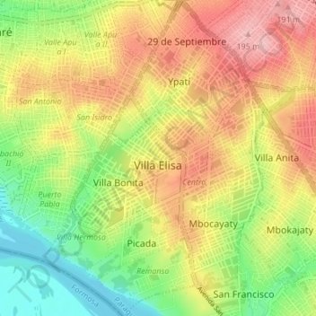
Name: Villa Elisa topographic map, elevation, terrain.
Location: Villa Elisa, Central Department, Región Oriental, Paraguay (-25.40069 -57.61461 -25.33941 -57.56680)
Average elevation: 120 m
Minimum elevation: 48 m
Maximum elevation: 192 m
The topographic characteristics of the Central Department vary among curves of 58 to 250 meters over the sea level. Villa Elisa has a soil covered by vegetation, it's a low and sandy land. Besides it has areas only populated by trees and bushes. It's a typical savanna, a good zone for the population.
Other topographic maps
Click on a map to view its topography, its elevation and its terrain.
Luque
Luque, Central Department, Región Oriental, Paraguay
Average elevation: 101 m
Ita District
Ita District, Central Department, Región Oriental, 110510, Paraguay
Average elevation: 118 m
Capiatá
Capiatá, Central Department, Región Oriental, Paraguay
Average elevation: 132 m
San Lorenzo
San Lorenzo, Central Department, Región Oriental, Paraguay
Average elevation: 134 m
San Rafael
Paraguay > Central Department > Lambaré
San Rafael, Lambaré, Central Department, Región Oriental, 110704, Paraguay
Average elevation: 120 m
Fernando de la Mora
Fernando de la Mora, Central Department, Región Oriental, Paraguay
Average elevation: 144 m