
Capiatá topographic map
Interactive map
Click on the map to display elevation.
About this map
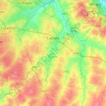
Name: Capiatá topographic map, elevation, terrain.
Location: Capiatá, Central Department, Región Oriental, Paraguay (-25.43913 -57.51670 -25.30783 -57.39835)
Average elevation: 132 m
Minimum elevation: 67 m
Maximum elevation: 196 m
Other topographic maps
Click on a map to view its topography, its elevation and its terrain.
Luque
Luque, Central Department, Región Oriental, Paraguay
Average elevation: 101 m
Ita District
Ita District, Central Department, Región Oriental, 110510, Paraguay
Average elevation: 118 m
San Lorenzo
San Lorenzo, Central Department, Región Oriental, Paraguay
Average elevation: 134 m
San Rafael
Paraguay > Central Department > Lambaré
San Rafael, Lambaré, Central Department, Región Oriental, 110704, Paraguay
Average elevation: 120 m
Fernando de la Mora
Fernando de la Mora, Central Department, Región Oriental, Paraguay
Average elevation: 144 m
Villa Elisa
Villa Elisa, Central Department, Región Oriental, Paraguay
Average elevation: 120 m