
okres Most topographic map
Interactive map
Click on the map to display elevation.
About this map
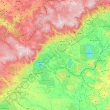
Name: okres Most topographic map, elevation, terrain.
Location: okres Most, Ústecký kraj, Severozápad, Tsjechië (50.41060 13.36154 50.71476 13.79428)
Average elevation: 450 m
Minimum elevation: 66 m
Maximum elevation: 939 m
Other topographic maps
Click on a map to view its topography, its elevation and its terrain.
Aš
Tsjechië > Severozápad > Aš
Aš, okres Cheb, Regio Karlsbad, Severozápad, Tsjechië
Average elevation: 625 m
Terezín
Tsjechië > Severozápad > Terezín
Terezín, okres Litoměřice, Ústecký kraj, Severozápad, Tsjechië
Average elevation: 164 m