Basque Country topographic map
Interactive map
Click on the map to display elevation.
About this map
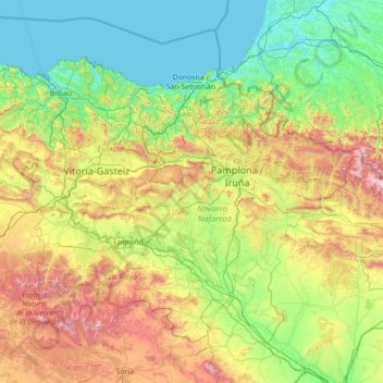
Name: Basque Country topographic map, elevation, terrain.
Location: Basque Country, Spain (41.90989 -3.45091 43.54743 -0.65272)
Average elevation: 560 m
Minimum elevation: -2 m
Maximum elevation: 2,626 m
The Basque Country region is dominated by a warm, humid and wet oceanic climate. The coastal area is part of Green Spain and by extension, the climate is similar for Bayonne and Biarritz as well. Inland areas in Navarre and the southern regions of the autonomous community are transitional, with continental Mediterranean climate, with somewhat wider temperature swings between seasons. The list only sources locations in Spain, but Bayonne/Biarritz have a very similar climate to nearby Hondarribia on the Spanish side of the border. The values do not apply to San Sebastián, since its weather station is at a higher elevation than the urban core, where temperatures are higher year-round and similar to those in Bilbao and Hondarribia.
Other topographic maps
Click on a map to view its topography, its elevation and its terrain.
Tudela
Spain > Navarre > Erribera / Ribera
Tudela, Erribera / Ribera, Navarre, 31500, Spain
Average elevation: 330 m
Montanejos
Spain > Valencian Community > Castelló / Castellón
Montanejos, l'Alt Millars, Castelló / Castellón, Valencian Community, 12448, Spain
Average elevation: 682 m
Castellnovo
Spain > Valencian Community > Castelló / Castellón
Castellnovo, l'Alt Palància, Castelló / Castellón, Valencian Community, 12413, Spain
Average elevation: 363 m
Viver
Spain > Valencian Community > Castelló / Castellón
Viver, l'Alt Palància, Castelló / Castellón, Valencian Community, 12460, Spain
Average elevation: 665 m
Segorbe
Spain > Valencian Community > Castelló / Castellón
Segorbe, l'Alt Palància, Castelló / Castellón, Valencian Community, 12400, Spain
Average elevation: 485 m
Cerro de Barbatón
Spain > Castile-La Mancha > Letur
Cerro de Barbatón, Letur, Castile-La Mancha, Spain
Average elevation: 1,278 m
Cumbre Vieja Nature Park
Cumbre Vieja Nature Park, GR 131, El Paso, Santa Cruz de Tenerife, Canary Islands, 38760, Spain
Average elevation: 1,664 m
San Cristóbal de La Laguna
San Cristóbal de La Laguna, Santa Cruz de Tenerife, Canary Islands, Spain
Average elevation: 408 m
Marbella
Spain > Andalusia > Costa del Sol Occidental
Marbella, Costa del Sol Occidental, Malaga, Andalusia, Spain
Average elevation: 216 m
Ugíjar
Spain > Andalusia > Comarca de la Alpujarra Granadina
Ugíjar, Comarca de la Alpujarra Granadina, Granada, Andalusia, 18480, Spain
Average elevation: 804 m
Laroles
Spain > Andalusia > Comarca de la Alpujarra Granadina > Nevada
Laroles, Nevada, Comarca de la Alpujarra Granadina, Granada, Andalusia, 18494, Spain
Average elevation: 1,028 m
Simon
Spain > Valencian Community > La Serranía > Andilla
Simon, Andilla, La Serranía, Valencia, Valencian Community, 46162, Spain
Average elevation: 1,056 m
Estany Tort de Peguera
Spain > Catalonia > Pallars Sobirà > Espot
Estany Tort de Peguera, Espot, Pallars Sobirà, Lleida, Catalonia, Spain
Average elevation: 2,444 m
Fuentepelayo
Fuentepelayo, Segovia, Castile and León, 40260, Spain
Average elevation: 875 m
Lomo Plata
Spain > Extremadura > La Coronada
Lomo Plata, La Coronada, Badajoz, Extremadura, 06460, Spain
Average elevation: 367 m
Ayllón
Ayllón, Segovia, Castile and León, 40520, Spain
Average elevation: 1,123 m
Terrer
Spain > Aragon > Comunidad de Calatayud > Terrer
Terrer, Comunidad de Calatayud, Zaragoza, Aragon, Spain
Average elevation: 650 m
Aroche
Spain > Andalusia > Sierra de Aracena > Aroche
Aroche, Sierra de Aracena, Huelva, Andalusia, 21240, Spain
Average elevation: 427 m
Madrid
Spain > Community of Madrid > Área metropolitana de Madrid y Corredor del Henares > Madrid
Madrid, Área metropolitana de Madrid y Corredor del Henares, Community of Madrid, 28080, Spain
Average elevation: 650 m
Boí
Spain > Catalonia > la Vall de Boí > Boí
Boí, la Vall de Boí, Alta Ribagorça, Lleida, Catalonia, 25528, Spain
Average elevation: 1,590 m
Isla Palma
Spain > Andalusia > Granada > Pinos Puente
Isla Palma, Pinos Puente, Comarca de la Vega de Granada, Granada, Andalusia, 18370, Spain
Average elevation: 554 m
Valenzuela
Spain > Andalusia > Cordova > Valenzuela
Valenzuela, Cordova, Andalusia, Spain
Average elevation: 334 m
dam wall
dam wall, Betancuria, Las Palmas, Canary Islands, 35628, Spain
Average elevation: 305 m
el Pla de Santa Maria
Spain > Catalonia > Tarragona > el Pla de Santa Maria
el Pla de Santa Maria, Alt Camp, Tarragona, Catalonia, 43810, Spain
Average elevation: 367 m
Cave of Altamira
Spain > Cantabria > Santillana del Mar > Herrán
Cave of Altamira, Acceso a las Cuevas de Altamira, Herrán, Santillana del Mar, Costa Occidental, Cantabria, 39360, Spain
Average elevation: 116 m
La Cueva
Spain > Castile-La Mancha > Montealegre del Castillo
La Cueva, Montealegre del Castillo, Albacete, Castile-La Mancha, Spain
Average elevation: 842 m
Ibiza
Ibiza, Sant Antoni de Portmany, Ibiza, Balearic Islands, Spain
Average elevation: 52 m
Vitoria-Gasteiz
Spain > Autonomous Community of the Basque Country > Vitoria-Gasteiz
Vitoria-Gasteiz, Gasteizko kuadrilla/Cuadrilla de Vitoria, Álava, Autonomous Community of the Basque Country, Spain
Average elevation: 626 m
San Justo
Spain > Castile and León > San Justo
San Justo, Galende, Castile and León, Spain
Average elevation: 1,332 m