
Pateros topographic map
Interactive map
Click on the map to display elevation.
About this map
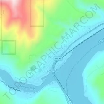
Name: Pateros topographic map, elevation, terrain.
Location: Pateros, Okanogan County, Washington, 98846, United States (48.04704 -119.91772 48.06481 -119.87839)
Average elevation: 334 m
Minimum elevation: 233 m
Maximum elevation: 676 m
Other topographic maps
Click on a map to view its topography, its elevation and its terrain.
Cathedral Peak
United States > Washington > Okanogan County
Cathedral Peak, Okanogan County, Washington, United States
Average elevation: 2,231 m