
Make a donation
Cathedral Peak topographic map
Click on the map to display elevation.
Make a donation
About this map
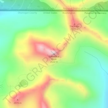
Name: Cathedral Peak topographic map, elevation, terrain.
Location: Cathedral Peak, Okanogan County, Washington, United States (48.98907 -120.18902 48.98917 -120.18892)
Average elevation: 2,231 m
Minimum elevation: 1,970 m
Maximum elevation: 2,606 m
Make a donation
Other topographic maps
Click on a map to view its topography, its elevation and its terrain.
Omak
United States > Washington > Okanogan County
Elevations around the area range from 780 feet (240 m) above sea level at the mouth of the Okanogan River to 6,774 feet (2,065 m) above sea level at the Moses Mountain. The average elevation is 843 feet (257 m) above sea level according to the United States Geological Survey (USGS). The Moses Mountain, with a…
Average elevation: 364 m
Tonasket
United States > Washington > Okanogan County
Tonasket is located along the Okanogan River at an altitude of 1,311 ft (400 m).
Average elevation: 342 m