
Edendale topographic map
Click on the map to display elevation.
About this map
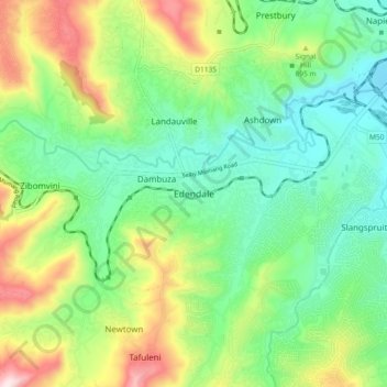
Name: Edendale topographic map, elevation, terrain.
Average elevation: 809 m
Minimum elevation: 632 m
Maximum elevation: 1,163 m
Other topographic maps
Click on a map to view its topography, its elevation and its terrain.
Wilgerfontein River
South Africa > KwaZulu-Natal > uMgungundlovu District Municipality > Msunduzi Local Municipality > Edendale
Average elevation: 781 m