
Engelberg topographic map
Interactive map
Click on the map to display elevation.
About this map
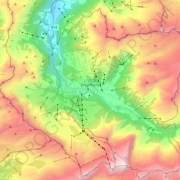
Name: Engelberg topographic map, elevation, terrain.
Location: Engelberg, Obwald, Suisse (46.76342 8.36130 46.87459 8.50688)
Average elevation: 1,806 m
Minimum elevation: 561 m
Maximum elevation: 3,233 m
La station d'Engelberg compte notamment le Titlis, au sud d’Engelberg, à 3 238 mètres d'altitude, qui est le plus haut sommet de la chaîne nord du col du Susten, entre l’Oberland bernois et la Suisse centrale.
Other topographic maps
Click on a map to view its topography, its elevation and its terrain.
Stalden (Sarnen)
Stalden (Sarnen), Sarnen, Obwald, 6063, Suisse
Average elevation: 784 m
Alpnachstad
Alpnachstad, Alpnach, Obwald, 6053, Suisse
Average elevation: 765 m