
Winterton topographic map
Click on the map to display elevation.
About this map
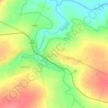
Name: Winterton topographic map, elevation, terrain.
Average elevation: 1,032 m
Minimum elevation: 991 m
Maximum elevation: 1,073 m
Other topographic maps
Click on a map to view its topography, its elevation and its terrain.
Bergville
South Africa > KwaZulu-Natal > Uthukela District Municipality > Okhahlamba Local Municipality
Average elevation: 1,132 m
Okhahlamba Ward 14
South Africa > KwaZulu-Natal > Uthukela District Municipality > Okhahlamba Local Municipality
Average elevation: 1,534 m
Mnweni
South Africa > KwaZulu-Natal > Uthukela District Municipality > Okhahlamba Local Municipality
Average elevation: 1,604 m
eNdumeni
South Africa > KwaZulu-Natal > Uthukela District Municipality > Okhahlamba Local Municipality
Average elevation: 1,652 m