
Make a donation
Bergville topographic map
Click on the map to display elevation.
Make a donation
About this map
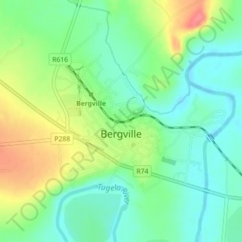
Name: Bergville topographic map, elevation, terrain.
Average elevation: 1,132 m
Minimum elevation: 1,105 m
Maximum elevation: 1,179 m
Make a donation
Other topographic maps
Click on a map to view its topography, its elevation and its terrain.
Sterkhorn
South Africa > KwaZulu-Natal > Uthukela District Municipality > Okhahlamba Local Municipality
Average elevation: 2,455 m
Hambrook
South Africa > KwaZulu-Natal > Uthukela District Municipality > Okhahlamba Local Municipality
Average elevation: 1,128 m
Winterton
South Africa > KwaZulu-Natal > Uthukela District Municipality > Okhahlamba Local Municipality
Average elevation: 1,032 m
Cathkin Peak
South Africa > KwaZulu-Natal > Uthukela District Municipality > Okhahlamba Local Municipality
Average elevation: 2,660 m
Make a donation
Okhahlamba Ward 14
South Africa > KwaZulu-Natal > Uthukela District Municipality > Okhahlamba Local Municipality
Average elevation: 1,534 m
Mhlwazini
South Africa > KwaZulu-Natal > Uthukela District Municipality > Okhahlamba Local Municipality
Average elevation: 2,935 m