
Make a donation
Sumy Oblast topographic map
Click on the map to display elevation.
Make a donation
Sumy Oblast
The Sumy Oblast is situated in the northeastern part of Ukraine. It is situated on a border of two historical regions of Ukraine — Cossack Hetmanate (annexed by Russia in the 18th century as Little Russia, previously known as Severia) and Sloboda Ukraine. Elevation is 110–240m above sea level. The area of the oblast (23,800 km2), comprises about 3.95% of the total area of the country.
Make a donation
About this map
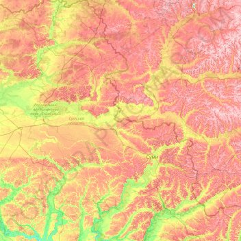
Name: Sumy Oblast topographic map, elevation, terrain.
Location: Sumy Oblast, Ukraine (50.11024 32.94260 52.36671 35.69266)
Average elevation: 170 m
Minimum elevation: 90 m
Maximum elevation: 271 m
Make a donation
Other topographic maps
Click on a map to view its topography, its elevation and its terrain.
Make a donation
Make a donation
Make a donation
Make a donation
Make a donation
Hoverla
In the 20th century, the mountain increasingly gained popularity as an extreme sports site. Some routes are classified as 1A in the winter period (from late autumn to May), according to the Soviet grading system. The most popular approach to the summit starts from the tour-basa Zarosliak on the mountain's…
Average elevation: 1,667 m
Make a donation
Make a donation
Make a donation
Verecke Pass
The pass is located in the Carpathian Mountains just where the oblasts of Lviv and Transcarpathia meet, on the spine of the Northeastern Carpathians, between the Latorica (or Latorytsia) and Opir river valleys and at the river divide or watershed between the Latorytsia and the Stryi. It has an elevation of 841…
Average elevation: 749 m
Make a donation
Make a donation
Make a donation
Make a donation
Bukovel
Ukraine > Ivano-Frankivsk Oblast > Polianytsia
Bukovel is the largest ski resort in Eastern Europe situated in Ukraine, in Nadvirna Raion, Ivano-Frankivsk Oblast (province) of western Ukraine. A part of it is in state property. The resort is located almost on the ridge-lines of the Carpathian Mountains at elevation of 900 m (3,000 ft) above the sea level…
Average elevation: 1,009 m
Make a donation
Make a donation
Make a donation
Make a donation
Hoverla
In the 20th century, the mountain increasingly gained popularity as an extreme sports site. Some routes are classified as 1A in the winter period (from late autumn to May), according to the Soviet grading system. The most popular approach to the summit starts from the tour-basa Zarosliak on the mountain's…
Average elevation: 1,667 m
Make a donation
Make a donation
Make a donation
Make a donation
Make a donation
Make a donation
Libknekhtovka
Ukraine > Autonomous Republic of Crimea > Керченський район > Чистопольское сельское поселение
Average elevation: 127 m
Make a donation
Make a donation
Make a donation