
Lady Bay topographic map
Click on the map to display elevation.
About this map
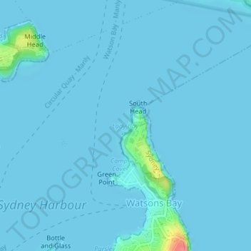
Name: Lady Bay topographic map, elevation, terrain.
Location: Lady Bay, Sydney, New South Wales, 2030, Australia (-33.83504 151.27879 -33.83494 151.27889)
Average elevation: 3 m
Minimum elevation: 0 m
Maximum elevation: 68 m
Other topographic maps
Click on a map to view its topography, its elevation and its terrain.
Penrith
Australia > New South Wales > Sydney > Penrith
Penrith is a city in New South Wales, Australia, located in Greater Western Sydney, 55 kilometres (31 mi) west of the Sydney central business district on the banks of the Nepean River, on the outskirts of the Cumberland Plain. Its elevation is 32 metres (105 ft).
Average elevation: 34 m
Mount Kuring-Gai
Australia > New South Wales > Sydney
Mount Kuring-gai is located approximately 7 km north of Hornsby. Its neighbouring suburbs are Berowra to the north, and Mount Colah to the south. Surrounded by bushland, it is bordered by Ku-ring-gai Chase National Park on the eastern side and by Berowra Valley Regional Park on the western side. There are…
Average elevation: 133 m
Davidson
Australia > New South Wales > Sydney
Davidson features uneven topography, in large part due to the area's origins as a mining quarry, as well as its proximity to Garigal National Park. Steep descents are evident in Stone Parade, Borgnis Street and Maitland Street, whereas more undulatory landscapes can be seen along parts of Prahran Avenue and…
Average elevation: 98 m
Pennant Hills
Australia > New South Wales > Sydney
The name Pennant Hills originally applied to the area now known as West Pennant Hills, located in the Hills District. However, when the northern railway line was built it passed through what is now Pennant Hills, so a suburb grew around the station and took on the name. The area around Thompsons Corner was…
Average elevation: 146 m
Woodford
Australia > New South Wales > Sydney
Woodford is a village in the Blue Mountains in New South Wales, Australia, about 90 kilometres west of Sydney. Its elevation is 609 metres (1,998 ft) above sea level. It is situated on the Great Western Highway and has a railway station (opened in 1868 as Buss's Platform) on the Main Western railway line…
Average elevation: 544 m
Smithfield
Australia > New South Wales > Sydney
Established in 1836, Smithfield was the first major settlement of the Fairfield LGA. The original 1838 summary plan of Smithfield shows the suburb laid out in a grid pattern with most of the streets having the same names as they do today. Its altitude ranges from 21 to 48 m (69 to 157 ft) above sea level.…
Average elevation: 33 m
Gregory Hills
Australia > New South Wales > Sydney
Gregory Hills is a suburb of Sydney in the state of New South Wales, Australia in Camden Council. The suburb was assigned on 1 August 2008. The suburb was named from the topography of the local area and from the original St Gregory's Chapel on the Marist Brothers land.
Average elevation: 109 m
Cammeray
Australia > New South Wales > Sydney
Prior to the 1920s, the suburb was known as Suspension Bridge reflecting the now Long Gully Bridge that joined Northbridge to Cammeray. Cammeray was slow to develop mainly due to its steep topography and remoteness from transport.
Average elevation: 66 m