
Ehrwald topographic map
Interactive map
Click on the map to display elevation.
About this map
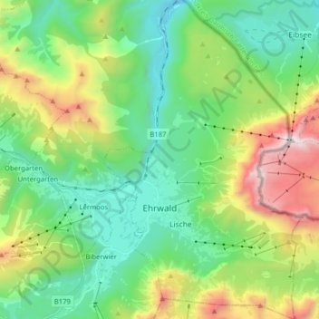
Name: Ehrwald topographic map, elevation, terrain.
Location: Ehrwald, Bezirk Reutte, 6632, Autriche (47.36124 10.89256 47.46805 10.99118)
Average elevation: 1,470 m
Minimum elevation: 828 m
Maximum elevation: 2,952 m
Other topographic maps
Click on a map to view its topography, its elevation and its terrain.
Bschlabs
Autriche > Bezirk Reutte > Pfafflar
Bschlabs, Pfafflar, Bezirk Reutte, 6647, Autriche
Average elevation: 1,668 m
Forchach
Forchach, Bezirk Reutte, Tyrol, 6670, Autriche
Average elevation: 1,325 m
Untergiblen
Untergiblen, Elbigenalp, Bezirk Reutte, Autriche
Average elevation: 1,233 m