Geolocate

Bronville topographic map

Interactive map

Click on the map to display elevation.

About this map

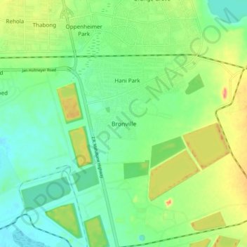
Name: Bronville topographic map, elevation, terrain.

Location: Bronville, Matjhabeng Local Municipality, Lejweleputswa District Municipality, Free State, 9463, South Africa (-28.03861 26.78222 -27.95861 26.86222)

Average elevation: 1,365 m

Minimum elevation: 1,340 m

Maximum elevation: 1,410 m

Other topographic maps

Click on a map to view its topography, its elevation and its terrain.

Harmony

South Africa > Free State > Lejweleputswa District Municipality > Matjhabeng Local Municipality

Harmony, Matjhabeng Local Municipality, Lejweleputswa District Municipality, Free State, South Africa

Average elevation: 1,333 m

Rietspruit Dam

South Africa > Free State > Lejweleputswa District Municipality > Matjhabeng Local Municipality

Rietspruit Dam, Matjhabeng Ward 3, Matjhabeng Local Municipality, Lejweleputswa District Municipality, Free State, South Africa

Average elevation: 1,364 m

Riebeeckstad

South Africa > Free State > Lejweleputswa District Municipality > Matjhabeng Local Municipality

Riebeeckstad, Matjhabeng Local Municipality, Lejweleputswa District Municipality, Free State, 9649, South Africa

Average elevation: 1,384 m

Odendaalsrus

South Africa > Free State > Lejweleputswa District Municipality > Matjhabeng Local Municipality > Odendaalsrus

Odendaalsrus, Matjhabeng Local Municipality, Lejweleputswa District Municipality, Free State, 9480, South Africa

Average elevation: 1,336 m

Hennenman

South Africa > Free State > Lejweleputswa District Municipality > Matjhabeng Local Municipality

Hennenman, Matjhabeng Local Municipality, Lejweleputswa District Municipality, Free State, 9445, South Africa

Average elevation: 1,397 m